Home
Links
Contact
Imprint
Data protection
SSASSCAL ObservationNet
Home
Biodiversity Observatories
Angola
Bicuar National Park
Cameia National Park
Candelela
Cusseque
Espinheira
Tundavala
Namibia
Aussinanis
Claratal
Dieprivier
Duruchaus
Featherlion
Ganab
Garnet Koppie
Gellap Ost
Giribes Leopard Rock
Giribesvlakte
Gobabeb
Haribes
Hartmann Plains
Karios
Kleinberg
Krumhuk
Marble Hill
Marienfluss Valley
Mile 46
Mutompo
Nabaos
Narais
Niko North
Niko South
Ogongo
Okamboro
Omano go Ndjamba
Otjiamongombe
Roessing Mountain
Rooisand
Sandveld
Sonop
Sophies Hoogte
Station 8
Toggekry
Ugab Hills
Vogelfederberg
Welwitschia Vlakte
Wlotzkasbaken
South Africa
Alpha
Cape of Good Hope
Eksteenfontein
Elandsberg
Goedehoop
Koeroegap Vlakte
Moedverloren
Nieuwoudtville
Numees
Paulshoek
Ratelgat
Remhoogte
Riverlands
Rocherpan
Soebatsfontein
Soebatsfontein exclosure
Yellow Dune - Grootderm
Zambia
Dongwe
Kafue National Park (KNP)
Luampa
Home
Paulshoek Infosheet
Ranking of the 1ha plots Paulshoek
Single hectare photos
Start page
Shows the list of all observatories. (Home)
Observatory
Info sheet
Shows available data of
Paulshoek
Data availibilty
Paulshoek
The list below shows which
other data
is available for this observatory.
BIOTA Books
Climate
Nearest weather station
Ranking of the 1ha plots
Time series of plant diversity
Single hectare photos
Soils
Remote Sensing
Photo gallery
PhotoGuide of Plants
EVI Viewer
0
1
2
3
4
5
6
7
8
9
0
1
2
3
4
5
6
7
8
9
Paulshoek (S24) - Photos for Hectare Plot 65
Structural information for
Hectar Plot 65
Ranking
24
Habitat
Gravelly, sandy slope with shrubby nonsucculents
Latitude
-30.391114
Longitude
18.280956
Altitude (m)
1048
Select Year
2008
2008
Sampling Area: 10x10Perspective: -Date: 24 Aug 2008
© Carolin Meyer
Photo-ID: 8146
Sampling Area: 20x50Perspective: ODate: 24 Aug 2008
© Carolin Meyer
Photo-ID: 8147
Sampling Area: 20x50Perspective: SDate: 24 Aug 2008
© Carolin Meyer
Photo-ID: 8148
Sampling Area: 20x50Perspective: WDate: 24 Aug 2008
© Carolin Meyer
Photo-ID: 8149


 Angola
 Bicuar National Park
 Namibia
 Aussinanis
 South Africa
 Alpha
Alpha Zambia
 Dongwe

 Paulshoek (S24) - Photos for Hectare Plot 65
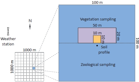


")

